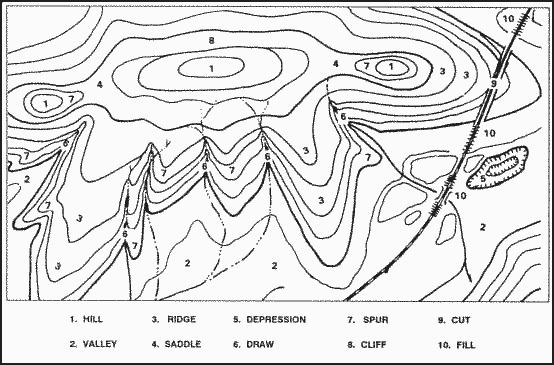
Terrain features do not normally stand a lone. To better understand these when they are depicted on a map, you need to interpret them. Terrain features are interpreted by using contour lines, the SOSES approach, ridgelining, or streamlining.
Using Contour Lines to Interpret Terrain
Contour lines are essential for understanding terrain features on a map. These lines connect points of equal elevation, helping to visualize the shape and elevation of the land. Closely spaced contour lines indicate steep terrain, while widely spaced lines suggest gentle slopes. By analyzing contour patterns, you can determine the presence of hills, valleys, ridges, and depressions.
Ridgelining and Streamlining for Better Terrain Analysis
Ridgelining and streamlining are two effective techniques for interpreting terrain. Ridgelining involves identifying the high ground by tracing the ridges on a map, while streamlining focuses on following watercourses to recognize valleys and low-lying areas. These methods help in navigation, route planning, and understanding elevation changes more effectively.